What Type of Accommodation and Meals Are Provided During the Manaslu Circuit Trek?
Accommodation
In Kathmandu:
- Tourist-standard hotel (private room with attached bathroom)
- Breakfast included
During the Trek:
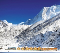
- Basic teahouses (family-run lodges)
- Shared rooms (twin or multi-bed) with common toilets
- Limited amenities (no heating; hot showers may cost extra)
- Simpler facilities than urban hotels—part of the authentic experience
Meals
- In Kathmandu: Breakfast only (Nepali/Western options)
- On the Trek: Three daily meals (breakfast, lunch, dinner)
- Breakfast & Dinner: Served at your overnight teahouse
- Lunch: En route at trailside lodges
Menu Options:
- Nepali staples: Dal Bhat (lentil curry with rice), Tibetan bread
- Soups, pasta, porridge, noodles, fried rice, eggs, and seasonal vegetables
- Limited meat options (vegetarian meals recommended at altitude)
Key Notes
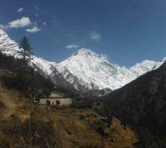
- Remote Location: Manaslu teahouses are less developed than Everest routes.
- Hygiene: Food is prepared with care, but manage expectations for variety.
- Packing Tips: Bring a sleeping bag liner, quick-dry towel, and toiletries.
What Pre-Trek Preparations and Briefings Are Provided?
Amazing Nepal Trek ensures you are fully prepared before beginning your adventure through our comprehensive orientation process:
Pre-Trek Briefing Includes:
Detailed Information Session covering:
- Complete day-by-day itinerary
- Elevation profiles and acclimatization schedule
- Safety protocols and emergency procedures
- Essential Documentation including:
- Printed information file with packing checklist
- Altitude sickness prevention guidelines
- Cultural etiquette tips
- Emergency contact numbers
Team Introduction:
- Meet your government-licensed trekking guide
- Introduction to support staff (if applicable)
- Q&A session to address personal concerns
Why This Matters:
- Builds confidence before hitting the trails
- Ensures alignment between trekkers and guides
- Clarifies all logistical and health considerations
- Establishes communication protocols
Note: Briefings typically occur at your Kathmandu hotel 1 day before departure. Bring any gear needing verification and your questions.
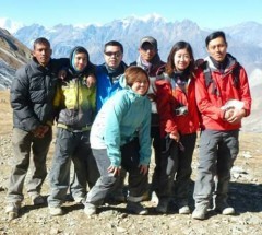
What Kind of Trekking Staff Will Support My Manaslu Circuit Trek?
Amazing Nepal Trek provides a complete professional team to ensure your safety, comfort and an enriching trekking experience:
Guide Services
- Government-registered professional guides
- Fluent English speakers with extensive local knowledge
- Trained in responsible and eco-friendly tourism practices
- Certified in wilderness first aid and altitude sickness management
- Experts in cultural interpretation and route navigation
Assistant Guide Support
- Provided for all groups only
- Additional support for managing varied pacing within groups
- Backup leadership in case of route splits or emergencies
Porter Services
- 1 porter provided for every 2 trekkers
- Strict 25kg maximum load (12.5kg per trekker)
- Properly equipped with quality gear and footwear
- Follow ethical treatment and fair wage policies
Staff Welfare Commitments
- All guides and porters fully insured
- Fair wages above industry standards
- Proper accommodation and meals provided during treks
- Regular training programs on safety and service excellence
Our Promise:
You'll be supported by professionals who not only know the mountains intimately but also care deeply about your experience and safety. Our crew members are the backbone of every successful trek.
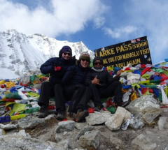
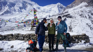
Will I Receive Recognition After Completing My Trek?
Upon successful completion of your trek with Amazing Nepal Trek, you will be awarded an official ANTE Adventure Certificate to commemorate your achievement.
Certificate Details:
Personalized Documentation featuring:
- Your full name
- Trek completion dates
- Maximum altitude reached
- Specific route completed
- Premium Quality printed certificate suitable for framing
- Official Validation with ANTE company seal and signature
Why This Matters:
- Serves as a lasting memento of your Himalayan journey
- Validates your physical accomplishment
- Many trekkers proudly display theirs at home or office
- Recognizes your perseverance through challenging terrain
Presentation Details:
Certificates are typically awarded during your farewell dinner in Kathmandu.
What Are the Group Size Options for the Manaslu Circuit Trek?
Amazing Nepal Trek offers flexible group arrangements to ensure optimal safety, personalized attention, and an enriching trekking experience.
Standard Group Size
- Small groups of 2 to 10 participants
- Ideal balance of social interaction and individual attention
- Ensures proper guide-to-trekker supervision
Solo Trekkers
- Custom private itineraries upon request
- Adjusted pricing and logistics
- Dedicated guide support
Large Groups (10+ people)
Customized planning including:
- Additional guide/porter support
- Modified teahouse accommodations
- Flexible pacing options
Requires early notification (minimum 15 days advance)
Why Group Size Matters
- Maintains 1:4 staff-to-trekker ratio for safety
- Allows proper resource allocation (accommodations, permits)
- Ensures quality experience without overcrowding
- Permits itinerary customization based on group dynamics
Note: We recommend booking early for solo treks or large groups to secure optimal arrangements. Our team will work closely with you to adapt plans to your group's specific needs and abilities.
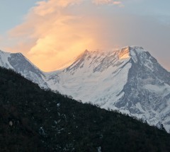
How is Acclimatization Managed on the Manaslu Circuit Trek?
The Manaslu Circuit Trek presents significant altitude challenges, reaching elevations above 5,000m. At Amazing Nepal Trek, we prioritize your safety through scientifically designed acclimatization protocols and expert medical support.
Our Acclimatization Strategy
- Gradual Ascent Profile
- Maximum daily elevation gain of 300-400m above 3,000m
- Strategic rest days at key locations (Samagaon, Samdo)
- "Climb high, sleep low" principle implementation
Professional Monitoring
- Mandatory rest at first signs of AMS symptoms
- Altitude Sickness Response Protocol
Preventive Measures
- Pre-trek medical consultation recommended
- Medicine advice available
- Hydration monitoring (3-4 liters daily)
First Aid Requirements
Carry personal first aid kit including:
- Altitude sickness medicine
- Pain relievers
- Anti-nausea medication
Emergency Response
- Immediate descent initiation for severe symptoms
- Portable oxygen available
- Satellite communication for evacuation coordination
Critical Trekker Responsibilities
- Maintain constant communication with guides
- Stay with assigned group at all times
- Report any discomfort immediately
- Follow all pacing instructions precisely
Our Safety Assurance
- 24/7 emergency evacuation coordination
- Daily weather and route condition updates
Why is Travel Insurance Mandatory for the Manaslu Circuit Trek?
At Amazing Nepal Trek, we require all trekkers to obtain comprehensive travel insurance before embarking on the Manaslu Circuit Trek. The remote nature and high-altitude environment of this trek make proper coverage essential for your safety and financial protection.
Essential Insurance Requirements
Your policy must specifically include:
- Emergency helicopter evacuation (minimum $100,000 coverage)
- High-altitude trekking coverage up to 5,500m
- Medical expenses (minimum $50,000 including hospitalization)
- Trip cancellation/interruption protection
- Lost/stolen baggage coverage
Critical Considerations
Helicopter Rescue
- Average evacuation cost: 3,000−5,000 without insurance
- Must cover remote mountain locations
Altitude Coverage
- Standard policies often exclude elevations above 3,000m
- Verify "trekking" or "mountaineering" is specifically mentioned
Documentation
- Carry both digital and physical copies of your policy
- Share insurance details with your guide during briefing
Our Recommendations
- Purchase insurance within 14 days of booking for cancellation benefits
- Select providers with Nepal experience
Ensure coverage includes:
- Pre-existing medical conditions (if applicable)
- Political evacuation
- Adventure sports activities
Important: We cannot permit trekking without verified insurance coverage. Our staff will check your documents during the Kathmandu briefing.
Are Permit Fees Included in the Manaslu Circuit Trekking Package Cost?
Yes, your Amazing Nepal Trek package includes all required government fees and permits for the Manaslu Circuit Trek. We handle all necessary paperwork to ensure full compliance with regulations.
Mandatory Permits Covered:
- Manaslu Conservation Area Permit (MCAP)
- Annapurna Conservation Area Permit (ACAP) (for circuit completion)
- Restricted Area Permit (RAP) for Manaslu region
- TIMS Card (Trekkers' Information Management System)
- Local Municipality Fees
Why This Matters:
- No hidden costs - All official fees are pre-paid
- Hassle-free experience - We process all documentation
- Legal compliance - Valid permits for restricted areas
- Local support - Fees contribute to trail maintenance and community development
Note: Your package covers only mandatory trekking permits. Personal expenses (snacks, drinks, tips) are not included.
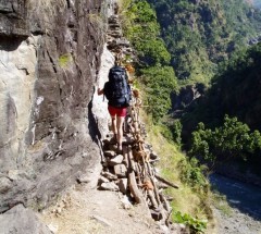
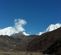
How Difficult is the Manaslu Circuit Trek?
The Manaslu Circuit Trek is considered one of Nepal's more challenging treks, requiring good physical fitness and mental endurance. While incredibly rewarding, this trek demands proper preparation due to its remote nature and high-altitude crossings.
Key Challenges:
High Altitude:
- Reaches 5,106m at Larkya La Pass
- Significant elevation gains between stops
- Thin air increases physical exertion
Trail Conditions:
- Unpaved, rugged paths with loose rocks
- Steep ascents/descents (particularly near the pass)
- Fewer developed trails compared to Everest/Annapurna routes
Remote Location:
- Limited teahouse facilities at higher elevations
- Basic medical services (carry personal first aid)
- Weather can change rapidly
Recommended Preparation:
- Physical Training (Start 2-3 Months Prior):
- Build endurance with 5-7 hour hikes carrying a 8-10kg pack
- Focus on leg strength (squats, lunges) and cardio (running, cycling)
Altitude Acclimatization:
- Consider shorter high-altitude treks first
- Discuss medicine with your doctor
- Practice slow, rhythmic breathing techniques
Mental Readiness:
- Prepare for basic accommodations
- Expect variable weather (cold nights, potential snow)
- Embrace the adventure - it's worth the effort!
Who Can Complete This Trek?
- Experienced trekkers
- Fit beginners with proper training
- Those comfortable with 6-8 hour hiking days
Why Choose Amazing Nepal Trek for Your Manaslu Circuit Trek?
As a government-approved trekking operator with over a decade of experience, we offer reliable and professional services for your Himalayan adventure.
Our Credentials
- Registered with Nepal Tourism Board
- Member of Nepal Mountaineering Association (NMA)
- Member of Trekking Agencies' Association of Nepal (TAAN)
- 10+ years operating treks in the Manaslu region
Booking Process
Deposit Requirement
- 20% of total trip cost to secure your booking
- Balance payable upon arrival in Kathmandu
Required Documents
- Passport copy (valid for 6+ months)
- Passport-sized photos (2 copies)
- Travel insurance policy copy
- Flight itinerary (arrival/departure details)
Payment Methods
Online options:
- Secure bank transfer
- Western Union
- Credit card payments
In-person options (Kathmandu):
- Cash (USD/NPR)
- Bank transfer
- Credit card
After Booking
Receive confirmation email with:
- Detailed payment receipt
- Pre-trek information package
- Equipment checklist
- Trip preparation guide
Is there an age limit for Manaslu Circuit Trekking?
The Manaslu Circuit Trek has no official age limit, but participants must be in good physical condition and prepared for high-altitude challenges. While children as young as 12 (children below 16 needs to be under parents supervision) and seniors in their 60s have successfully completed the trek, all trekkers should be capable of hiking 5-7 hours daily with a light daypack. We strongly recommend consulting your physician before booking, especially for those over 60 or with pre-existing medical conditions, to assess altitude readiness and discuss preventive medications.
Physical preparation is essential regardless of age. The trek's difficulty comes from sustained climbs to 5,106m at Larkya La Pass, rugged trails, and basic mountain accommodations. Prior multi-day hiking experience is highly recommended, and all participants should train for several months beforehand, focusing on endurance and leg strength. Families with children or older trekkers may opt for longer itineraries with extra acclimatization days.
Amazing Nepal customize support based on each trekker's needs. Our guides are trained in altitude sickness recognition and emergency response, with oxygen and evacuation plans in place. While we welcome determined trekkers of all ages, your safety remains our top priority - we may recommend alternative routes if the standard circuit appears too challenging during pre-trek assessments.
 54 Reviews on Google
|
54 Reviews on Google
|  30 Reviews on Facebook


.webp)


 WhatsApp Us


